|
||||||||||||
| ||||||||||||
Dams and ReservoirsOverviewAfter analysis of the basin, only three big dams / reservoirs appear to have a strong influence on the flood events on Maritza and Tundja.
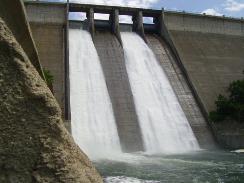
These dams with large retention capacity (above 100 Mm3) receive direct inflow from rivers of Maritza and Tundja basin with significant upstream watershed (above 500 km2). This does not mean that the other reservoirs do not influence the flood regime of the watershed, as we will see later. But at this stage we meant that only these three big Dams and reservoirs may be overpassed by large floods (such as Topolnitza reservoir in 2005) and thus provide a strong discontinuity effect on the flood generation. Other dams or reservoirs within the watershed have large capacities but gather waters form much smaller sub-basins (or accumulate waters from other watersheds through artificial channels or pipes) and their effect during rather large floods may be considered as secondary when compared with these three “big” ones. The statistics of river discharges after the settlement of these dams have been largely modified and it is obvious that Dams have a positive impact for flood protection at least until a certain level of flood intensity. The flood of August 2005 (cyclone Ihtiman) where Topolnitza dam was overtopped which led to big damages downstream, should remind us this fact. For flood management we are interested mainly in two aspects of these dams and reservoirs.
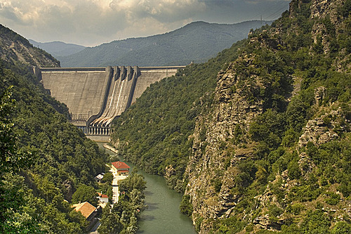
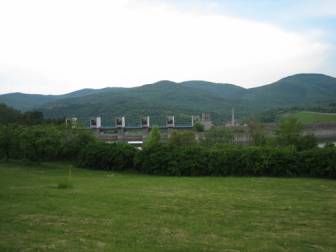
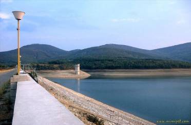
1. The Topolnitsa reservoirThe Topolnitza reservoir was constructed in 1963. It gathers waters from Topolnitza and Mativir rivers in the mountainous upper part (North western) of Maritza basin about 60 km upstream from Pazardjik.
Several data were obtained in order to model and analyse the reservoir operations during floods:
2. The Vacha DamThe Vacha dam is an electrical dam on the Vacha river of 226 Mm3 Capacity constructed in 1975. It is followed in cascade by the Kritchim dam which is of much lower capacity (20 Mm3) and which would be rapidly overpassed if the Vacha dam was itself overwhelmed. Kritchim dam may thus be considered as transparent for flood propagation in the Vacha cascade.
No data was obtained on this Dam which was excluded of the scope of this project. The Vacha river study and integration in the modelling system will be part of a follow-on project. 3. The Jrebchevo ReservoirThe Jrebchevo reservoir was constructed in 1973. It is a mixed irrigation / electrical dam on the Tundja river of 400 Mm3 capacity.
As for Topolnitza reservoir various data were obtained for analysis:
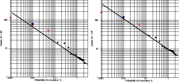
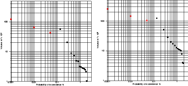
Analysis performedOnly the Topolnitza reservoir was modelled in the project. Vacha Dam and Jrebchevo reservoir are both out of the scope of the modelled system. However because of the necessity to run flood scenarios we needed to estimate in which conditions the Jrebchevo reservoir could be overtopped with a 100 Mm3 security volume. Beside, the 2005 event data were used for calibration of the reservoir model of Topolnitza within the global hydrological and hydraulic model of the Maritza watershed. In order to asses the possibility of dam overtopping accounting for the defined “security volumes”, the daily inflows have been used to perform a statistical analysis on the probability of high volume inflows for periods of one to 5 days. Actually with only 6 years of data such an analysis cannot be considered as very sound. The idea was also to compare the probabilities computed, with the values which were used as project values for the computation of the weirs and gates. We provide hereafter the results of this analysis (adjustment of extreme values on a Log–Log law): On these graphs we reported the computed return values of inflows which were obtained by the engineers during the Dams designing project in order to compare their estimations with ours.
Note that for Zrebchevo Dam, our analysis made upon only 6 years of data is totally relevant with the statistics elaborated during the design project of the reservoir. For Topolnitza, where we have the 2005 flood taken into account in our statistics analysis, we can see that the design values are positionned largely underneath the statistical trend that may be chosen for adjustment of our sample; However, as the design data show, the event of 2005 would correspond to a 100 year type event, which is in our opinion close to the reality. Consequently we will also consider that the design statistical laws are relevant for Topolnitza. For Zrebchevo dam, we may conclude from this analysis, that a 100Mm3 security volume prevents the overtopping of the claps for events of return period below 500 years. For 1000 years return period floods the Reservoir would open its gate after one day which would provide downstream discharges of about 1000 m3/s for several hours. Consequently, the “1000 year scenario” on upper Tundja will have to be done with a 1000 m3/s discharge. TheTopolnitza dam was already overtopped in the past. The adopted 45 Mm3 security volume corresponds to an inflow event of about 25 years return period. The full opening of the claps would not occur before 100 year return period events. In 2005, the flood occurred when the reservoir was full after several flood events. Consequently they had to open the four claps of the reservoir which lead to more than 600 m3/s discharges at the peak of the flood. Conclusions about Dams and reservoirsIn 2005 Topolnitza was overtopped by a severe flood of say, 100 year return period. Actually, the reservoir was full when the flood came as the winter, spring and the beginning of summer had been very wet. But, even if it had not been full, we are quite sure that the reservoir would also have been overtopped, while less severely and with minor damages downstream. The operation rules during floods, which could be somewhat upgraded, could only slightly reduce the damages due to Dam overtopping. This event has to remind us that the reservoirs and dams do not protect the flood plains downstream for extreme events but only for the more frequent ones. From our analysis based upon 7 years of data and the design values taken for these dams we may say: Topolnitza reservoir with 45 Mm3 of security volume gives a total protection for flood under 25 years, a good protection (by reducing their effect) for flood between 25 to 75 years of return period and will be nearly transparent (offering some time lag however for alarm) to extreme events over 100 years of return period. The Jrebchevo reservoir is the biggest of the three dams, with the smallest catchment area, and because of its surface, the one with the most retention and security volume. Obviously the Jrebchevo dam provides a full protection of the downstream area even for very extreme floods but until which extent? From our analysis based upon 7 years of data and corroborated by the project floods used to design the dam structure, we can consider that floods over 1/500 years probability would start overpass the dam and that 1/1000 years flood would deliver more than 1000 m3/s into the Tundja river, which of course would not handle it. The Vacha Dam with its 25 Mm3 of security and its 1465 sqkm basin in the Rhodopa mountains will provide security only for 10 to 20 years return floods. In 2005, two things protected the population downstream from having it overtopped : i) the rains in the Vacha watershed were less intense than in Western Rila mountains and ii) the Vacha waterlevel was well below its security level when the event occurred. However we have several events in our records where we can see that Vatcha dam had to open its claps due to water rises in the retention lake during localised floods. The proximity of the Vacha river confluence with Plovdiv should suggest to take some specific warning measures for this river and its dams. Note that the design flood used for Vacha was more than 2700 m3/s (10-4 probability) which gives obviously a 100 year return period flood over 1000 m3/s. of which only a few part would be dampened. |
||||||||||||
|
||||||||||||
 The upstream watershed or drained area is about 1381 km2
 The upstream watershed of Vacha dam in the Rhodopes mountains is 1465 km2
 The upstream watershed of Jrebchevo dam in the
Balkan mountains is about 800 km2.. It is located just upstream the city of Banya and downstream another
big dam (Koprinka dam, 140 Mm3, which itself intercepts waters flowing from the Balkan mountains for another 600 sq km)
The upstream watershed of Jrebchevo dam in the
Balkan mountains is about 800 km2.. It is located just upstream the city of Banya and downstream another
big dam (Koprinka dam, 140 Mm3, which itself intercepts waters flowing from the Balkan mountains for another 600 sq km)
 The security rules have set recently to 100 Mm3 the
reserve capacity bellow the crest for flood management.
The security rules have set recently to 100 Mm3 the
reserve capacity bellow the crest for flood management.