|
||||||||||||||||||||||||||||||||||||||||||||||||||||||||||||||||||||||||||||||||||||||||||||||||||||||||||||||||||||||||||||||||||||||||||||||||||||||||||||||||||||||||||||||||||||||||||||||||||||||
| ||||||||||||||||||||||||||||||||||||||||||||||||||||||||||||||||||||||||||||||||||||||||||||||||||||||||||||||||||||||||||||||||||||||||||||||||||||||||||||||||||||||||||||||||||||||||||||||||||||||
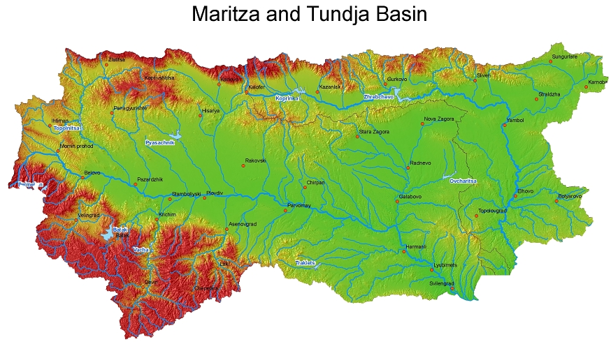
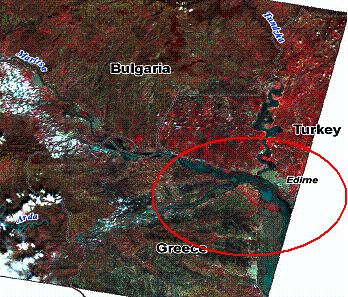
Hydrology of Maritsa and TundzhaThe Maritsa/Meric River is the biggest river on the Balkan peninsular. Maritsa catchment is densely populated, highly industrialized and has intensive agriculture. The biggest cities are Plovdiv on the Bulgarian territory, with 650.000 citizens, and Edirne on the Turkish territory, with 231 000 citizens. The biggest tributaries are Tundzha and Arda Rivers, joining Maritsa at Edirne. Within Maritza and Tundja basin, a significant number of reservoirs and cascades were constructed for irrigation purposes, and for Hydro electricity production.
The climatic and geographical characteristics of Maritsa and Tundja River Basins lead to specific run-off conditions: flash floods, high inter-annual variability, heavy soil erosion reducing the reservoirs' capacities through sedimentation, etc. The destructive forces of climatic hazards, manifesting themselves in the form of rainstorms, severe thunderstorms, intensive snowmelt, floods and droughts, appear to increase during recent years. After more than 20 years of relative minor floods during wet seasons, large floods started to occur more often since the end of the 90’s. Theses years of absence of large floods resulted in negligence of political action and financial investment for structural and non-structural flood mitigation measures and maintenance of the river bed and its embankments. The morphology of both river systems is somewhat similar: Maritza flows between Pazarjik to Parvomay in a large flat plain where flood expansion would be very large if no dike contained the flows. However these dikes are not very well maintained out of the main cities, which actually protect them in a certain way ; In 2005 the large inundation upstream Plovdiv certainly prevented Maritza from overtopping the dikes in the city ! Downstream Parvomay, the relief becomes more hilly and the flood plains are more reduced in size until the Greek-Turkish borders where the plain becomes again wide and flat. On Maritza in Bulgaria, the two main risks concern Plovdiv and Svilengrad where thousand of people live in houses settled in flood prone areas behind dikes which may be overtopped or bypassed.
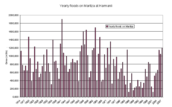
The Tundja Flood plain is also very large downstream Banya at the outflow of the Jrebchevo Dam but with a marked slope down to Mutchuritza confluence. From Yambol to Elhovo the flood plain is very large and very flat and Tundja river, which has been elsewhere channelised, is let free to meander within large forested areas until Elhovo city. Downstream Elhovo the river goes sloppy again but through an unpopulated hilly relief which constraint its discharges in narrow cross sections down to the Turkish border. In Turkey the river gets again into a large and flat flood plain where it meanders (though it has been channelised) until Edirne where it joins Maritza. Yambol city is theoretically protected by high dikes which can handle 800 m3/s discharges. Elhovo downstream is much less protected and may be flooded in some areas with less than 200 m3/s. New settlements in flood prone areas have increased the socio-economic risks in both cities. 1 Some Historical ElementsThe following graph of flood records at Harmanli show that before the 60’s - – the flood discharges look higher than after, when most dams and reservoir were constructed. The period between 60’s and 80’s is characterized by relatively high flood activities, but the higher discharges look lowering down. several flood events occurred, however with discharges above 1200 m3/s. After 1984 there is a period of about 14 consecutive years with hardly any significant flood events. Floods start again to show after 1998 with a climax period in 2005,2006 and 2007.
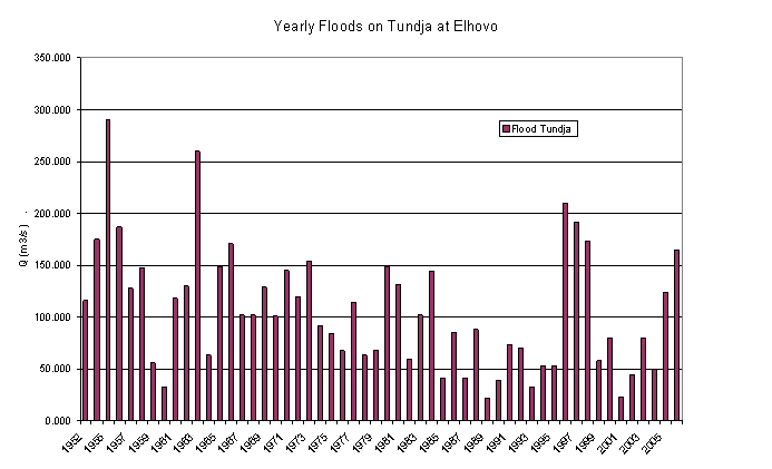
On Tundja river, the time series are less deep in time. So we cannot process the same analysis. The morphology of Tundja flood plain indicates that very large floods may have happened in the past along the river. In all cases, however, the construction of the Jrebchevo Dam in the early 1970s modified dramatically the river regime as it cut for Yambol city more than half of the watershed, and obviously the most rainy one. For Elhovo city the watershed reduction will amount to a bit less than a half .
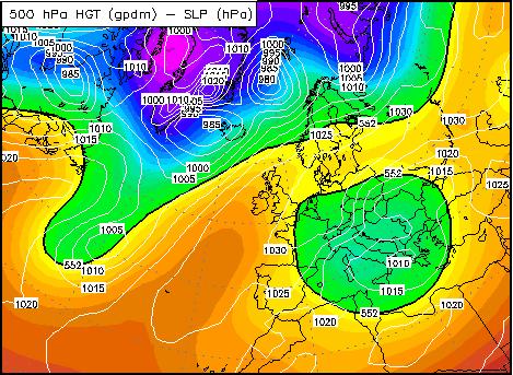
2 Meteorological Events Leading to FloodsAbundant precipitations are the primary event leading to floods. They either come in the form of rain over moist soil which runs off or come in the form of snow which may, in some cases, melt rapidly due to exceptional warming. In all cases heavy precipitations are associated with the development and evolution of Mediterranean cyclones in the vicinity of the Balkan Peninsula. Basically the Maritza basin faces four types of Floods:
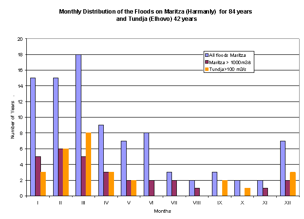
2.1 Flood SeasonalityThe following figure presents the monthly cumulative occurrence of floods on Maritza and Tundja. Only the annual maxima are considered. The annual distribution shows that winter floods (cold season, with or without snow melting) are largely predominant to convective types of floods, for moderate as well as for large floods. Note nonetheless that the worst floods during the last 8 years are very untypical: The most severe floods accured in August 2005 (upper part of Maritza) and Novembre 2007 (lower part of Maritza and Turkey): these months showed no occurrence of large floods before. One of the questions which may rise from these recent events is about the impact of the climate change on the intensity and seasonality of the floods.
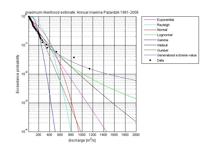
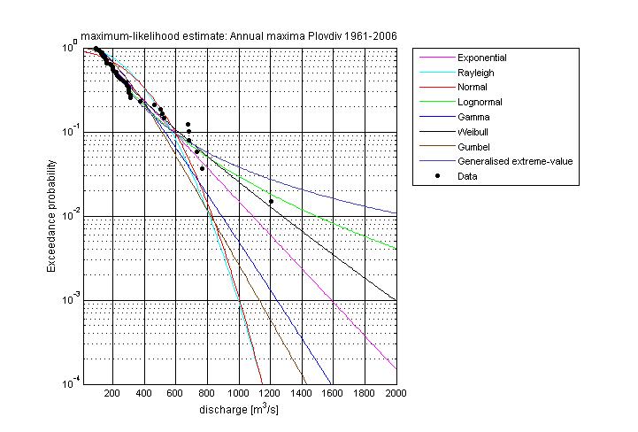
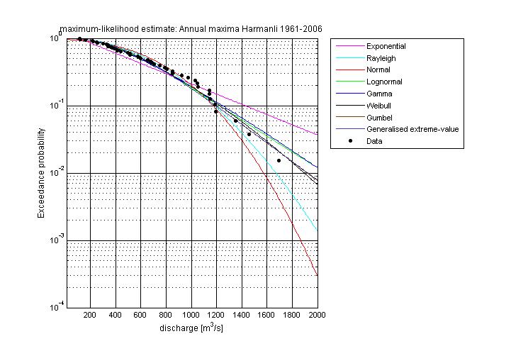
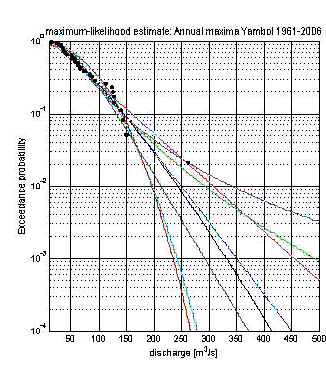
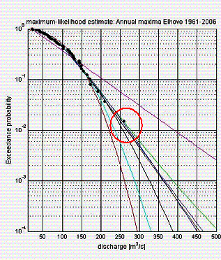
2.2 Flood FrequenciesWe performed numerous statistical analysis on rains and discharges records at most of the hydro-meteorological stations. The data were provided mainly by NIMH. The technique is to fit the observed records along statistical laws which are known to well represent the probability of extreme hydrological events. We show hereafter some of the statistical adjustment we made with several of these statistical laws using dedicated software from HKV consultants.
The raw results from our statistical analysis have been then re-analysed in order to have a coherent set of values between the different stations, reflecting the physical processes and the behaviour of the different tributaries on which we performed also such analysis. More specifically we corrected some incoherences on discharges data probably due to some approximations in the used rating curves at stations, and we accounted for the dam and reservoirs influences on statistics. The very large number of reservoirs and dams, throughout the watershed, has modified the statistics of floods for the recent years as the most frequent floods are now much dampened by the water retention accumulated capacity within these reservoirs. However this dampening, which influences the statistics of floods up to a certain return period, would not hold for the most extreme floods (over 100 years return period) as most of the small retention dams would be overtopped for such extreme events. The final results of our analysis are:
The same type of analysis was also performed on the tributaries of both rivers Because of the variability of the basins in surface and shape and because of the too short period of data samples the statistical results were quite incoherent between each other. So we had to make a large cross coherence analysis between the basin Area, their morphology, the observed data and the statistical parameters by optimising the function: Qn = Cn x Km x Area f
Where : Qn = discharge with n % probability ; (1/n = return period) Q5 = 1/ 20 years ; Q1 = 1/100 year probability Q0,1 = 1/1000 year probability Cn takes values depending on n only Km takes values depending on the hypsometry of the basin only f : varies between [0,5 and 0,6] depending on land cover, hypsometry and shape…
We actually defined only two different classes of tributaries with two different values for Km and f Our final result for the tributaries are given in the following table :
(F) : Not steep Basin (others are considered as steep) |
||||||||||||||||||||||||||||||||||||||||||||||||||||||||||||||||||||||||||||||||||||||||||||||||||||||||||||||||||||||||||||||||||||||||||||||||||||||||||||||||||||||||||||||||||||||||||||||||||||||
|
||||||||||||||||||||||||||||||||||||||||||||||||||||||||||||||||||||||||||||||||||||||||||||||||||||||||||||||||||||||||||||||||||||||||||||||||||||||||||||||||||||||||||||||||||||||||||||||||||||||
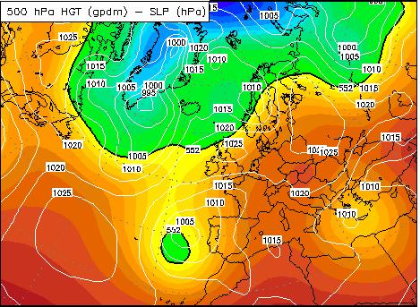
 A cut-off cyclonic system makes for a series of smaller
Mediterranean cyclones which move through the country from the south to the north (type C2). There are a couple of
days of strong precipitations
A cut-off cyclonic system makes for a series of smaller
Mediterranean cyclones which move through the country from the south to the north (type C2). There are a couple of
days of strong precipitations
 The moisture comes either from the Aegean or the Black Sea.
The mountainous regions are more likely to suffer heavy convective precipitations in late spring. In this occasion
it is the region of Strandja, Sakar and Rodopi where the biggest precipitation amounts are registered on 11 May.
The reason is the stationary paths of MCSs. Many of them end-up going through southeast Bulgaria.
Precipitations as high as 70mm/24h are registered in the region of Haskovo on 11.05 and as high as
80-140mm on 11-12.05 in Rhodopi.
The moisture comes either from the Aegean or the Black Sea.
The mountainous regions are more likely to suffer heavy convective precipitations in late spring. In this occasion
it is the region of Strandja, Sakar and Rodopi where the biggest precipitation amounts are registered on 11 May.
The reason is the stationary paths of MCSs. Many of them end-up going through southeast Bulgaria.
Precipitations as high as 70mm/24h are registered in the region of Haskovo on 11.05 and as high as
80-140mm on 11-12.05 in Rhodopi.